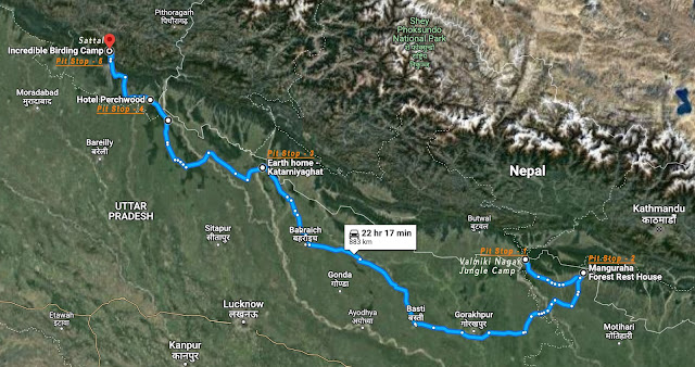
Meander Through The Terai
24 Feb - 27 Feb, 2023
"The more I read, the more I acquire, the more
certain I am that I know nothing."
― Voltaire
Terai, the more I read about it,
the more fascinating it seemed, yet so little I seemed to know. Apart from a few
isolated trips in the past to some of the hot spots, I still needed to get an
authentic feel. This drive was my chance! Thus we headed out from Kolkata to Valmiki Tiger Reserve (Episode -1) and from there, the idea was to drive northwest
across the Terai Arc.
The Urdu word (तराई) tarāʼī means "lands lying at the foot of a watershed" or "on the banks of a river; low ground flooded with water, valley, basin, marshy ground, marsh, swamp; meadow". In Hindi, the region is called (तराई ) 'tarāī' meaning "foot-hill".
The Terai or Tarai is a lowland
region in northern India and southern Nepal that lies south of the outer
foothills of the Himalayas, the Sivalik Hills, and north of the Indo-Gangetic
Plain. This lowland belt is characterised by tall grasslands, scrub savannah,
sal forests and clay-rich swamps. The corresponding lowland region in West
Bengal, Bangladesh, Bhutan and Assam in the Brahmaputra River basin is called
'Dooars'. .... Wikipedia
My initial plan was to drive into Nepal through Raxaul and go
westwards along the Himalayan foothills. But detailed enquiry revealed that
Nepal's road conditions and support system could be a bottleneck. Hence dropped
the idea and chose to drive along the Indo-Nepal border.
 |
Meandering across the Terai
|
We started our 'Terai Pilgrimmage' on the banks of
the Pandai River at Manguraha, after having spent 3 days, driving in and around Valmiki Tiger Reserve. Since it was the sugarcane harvesting season
(during Feb - March), choosing the correct route was critical to avoid hold-ups
due to harvest movements. On our way to Valmiki Nagar, at Bagaha, we experienced getting
stuck between trucks, tractors, bullock carts, To-To and every other conceivable form
of transport. A railway crossing that took us well over an hour to get past.
Complete chaos initially, with everyone rushing to the crossing from all directions, no one to control the traffic; eventually, some order emerged, and we
managed to squeeze out of the impasse. Looking back it was a classic 'closed loop congestion control' in action, a very inefficient one ofcourse!
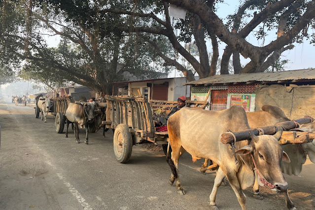 |
Bullock Cart Convoy headed to Sugarcane fields
|
Katarniaghat, was the destination in our northward journey, roughly 520 km from Manguraha. Google Maps,
projected the time duration as 12hrs 30mins; add another hour for hygiene breaks
and refreshments, approximately a 14hour drive, without any major hold-ups. Thus to ensure we reached our destination before sunset,
we drove out of Manguraha well before sunrise, adequately cautioned about the winter fog
and the congestion around sugar mills. After local consultations, the plan was to get to
NH 27 (National Highway 27 is an east-west highway that starts at Porbandar and ends at Silchar), a double carriageway, at the earliest, and head towards the holy city of
Ayodhya, take the Ayodhya bypass towards Gonda, and then drive onto Bahraich and
eventually Katarniaghat.
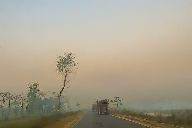 |
Misty mornings and sugarcane convoys on our way to NH27
| 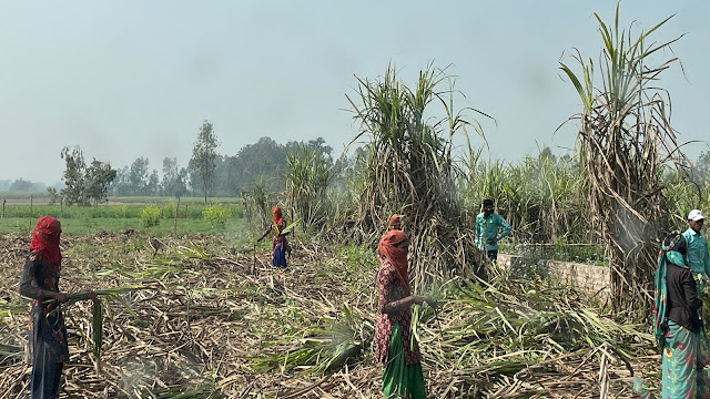 | Sugarcane harvesting - a community affair
|
|
|
The country landscape throughout the drive was like an unfolding poetry. A foggy winter morning, veiled by the mist, wheat & mustard fields interspersed with sugarcane plantations. Canals & rivers flanked with blooming Silk-Cotton and Palas (Flame of the forest) crisscrossed the fields like a crossword puzzle. In the dim light of daybreak, convoys of tractors and bullock carts were carting freshly harvested sugarcane. As the sun beamed across the horizon behind us, we crossed from Bihar into Uttar Pradesh, and quite instantaneously, the highway transformed into a wide double-carriageway.
%20lined%20paths_IMG_1702.jpg) |
Simul (Indian Silk Cotton) lined pathways
|
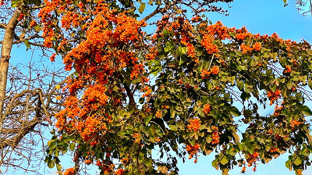 |
Ornate bloom of Palash (Flame of the Forest)
|
We soon zoomed past the ancient cities of Kushinagar and
Gorakhpur. Lord Buddha delivered his last sermon and attained
"Mahaparinirvana"
at Kushinagar. Frankly, I wasn't aware until pointed out by Runa.
Impressive memory indeed!
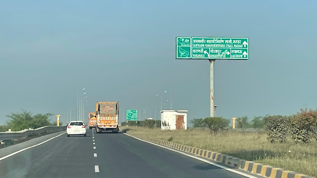 |
NH 27 towards Ayodhya - National highways across Uttar Pradesh are a pleasure to drive
|
Kushinagar,
Gorakhpur, and Ayodhya stood witness to the golden age of India, and formed an important part in the glorious
ancient history dating back to 600 BC. We came across
signboards with heritage landmarks as we drove past these cities. Kushinagar - Gorakhpur - Gonda (395 Km) the drive was bliss. From Gonda, closer to Bahraich the road once again turned into a single-carriageway. The final stretch (Mihinpurwa - Bichia) was quite nice, roughly 35
Km, passing through Katarniaghat Wildlife Sanctuary.
On the advice of a forester
friend, we checked into Earth Home, at the edge of Katarniaghat Wildlife
Sanctuary, at 1630 hrs on 24th February 2023.
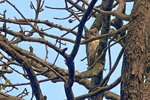 |
Dusky Eagle-Owl at Earth Home Katarniaghat (Pic - courtesy Mr Suraj Shukla)
|
Earth Home Katarniaghat, was our home for
two nights. We planned to visit the birding hotspots around Katarniaghat and get
a first-hand feel of the landscape. During the day's commute, we came across the Mailani -
Bahraich meter gauge train that passes right through the Katarniaghat Wildlife
Sanctuary and Dudhwa National Park—built by the British in 1911 to transport timber logs
from the Terai forests. Though the train has had a wildlife calamity-ridden history, the Mailani railway section is beautiful. I am given to understand that regular passenger services will stop
soon, and it shall become a heritage tourism ride.
 |
Large number of barrages constructed to divert water for irrigation
|
The most conspicuous part of the Terai experience was to see how the
fertile floodplains have transformed into densely populated regions due
to large-scale agriculture leading to a mosaic of villages, fast-growing
townships, and a diversity of ecosystems. We witnessed vast stretches of irrigated land aided by irrigation systems leveraged off rivers diverted from their natural course. Despite all the development,
some dense natural forests and a few riverine grasslands remain,
supporting one of the most spectacular collections of wildlife. The
fragile Terai is home to around 86 species of mammals, 600 species of
birds, and over 2,100 species of flowering plants. Today almost 14
wildlife sanctuaries thrive within this region, and this terrain hosts
the largest population of tigers in the world.
On 25th
February, with a local guide, we visited the major water bodies along
the banks of the Girwa River and the Kailashpuri Reservoir. Post lunch,
we walked along the fringes of Katarniaghat WLS. We encountered a decent
population of waders and other birds around the reservoir, all three
species of Hornbills (Great, Oriental Pied and Indian Grey), Himalayan
Griffon, Eurasian Griffon, the usual Primates (Rhesus Macaque and Grey/Himalayan Langur), a few Gharials and a lone Mugger. There were
no signs of the Gangetic Dolphins.
Overall, an unsettling feeling as more areas are carved out of the Terai for development and irrigation while the grassland that sustains every form of life continues to deplete. However, WWF, a glimmer of hope, has been actively pioneering conservation activities ensuring habitat integrity and protected area connectivity across the landscape for wildlife populations while providing alternate livelihoods to local communities and handling human-animal conflicts. It was good to meet some WWF folks and get a feel for their dedication & commitment. And thus feel reassured.
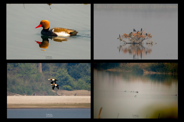 |
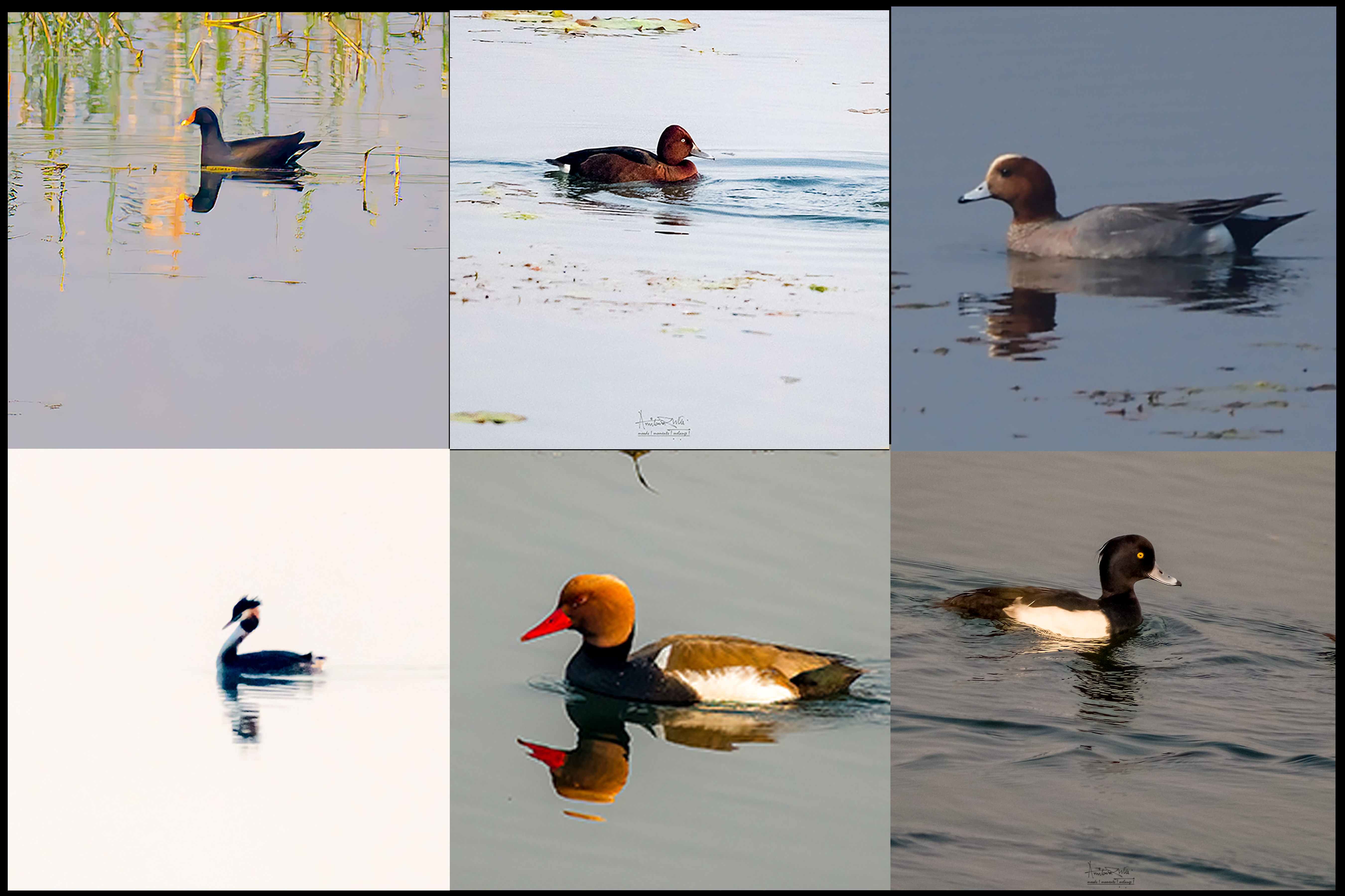
Top left clockwise - Red-crested Pochard, Greater Cormorant, Flock of Tufted Duck, Rudy Shelduck
|
 |
Top left clockwise - Eurasian Moorhen, Ferruginous Duck, Eurasian Wigeon, Tufted Duck, Red-crested Pochard, Great Crested Grebe.
|
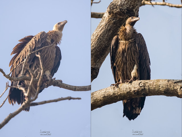 |
Eurasian Griffon Himalayan Griffon
|
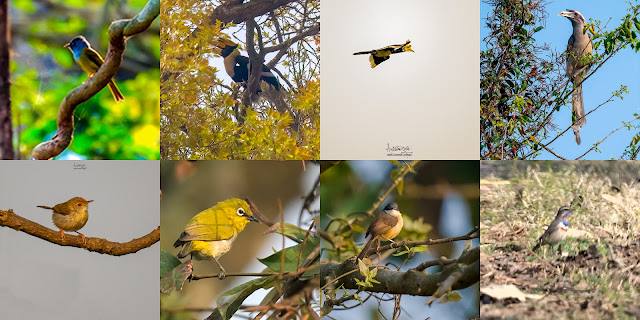 |
Top left clockwise - Grey-headed Canary-Flycatcher, Great Hornbill, Oriental Pied Hornbill, Indian Grey Hornbill, Bluethroat, Ashy Prinia, Indian White-eye, Common tailorbird.
|
Early morning on 26th February 2023, we checked out
of Katarniaghat and started our drive towards Khatima (Uttarakhand), at a
distance of roughly 190 Km. We took NH 731 via Palia Kalan and merged into NH
730 until we reached Puranpur and took MDR 39C, which goes through Pilibit Tiger
Reserve for about 15 Km, leading to the northern flank of Sharda Sagar
Reservoir. The course took us through spectacular stretch of forests between two National Parks
- Pilibit Tiger Resereve (India) on the left and Shuklaphanta National Park (Nepal) on
the right. After crossing the sanctuaries, we drove along the northern dyke of
the Sharda Sagar Reservoir, built over the Kali (Sarayu) River for about 15 Km.
This stretch of 30 Km was scenic and enchanting.
 |
| Sharda River channel passing through Pilibit Tiger Reserve |
|
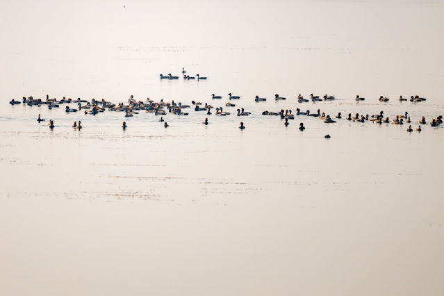
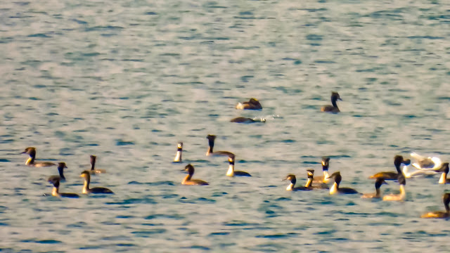
Sharda Sagar reservoir had a large conglomeration of waders. There must
have been over 1000 birds consisting of Red-crested Pochard, Coot,
Northern Pintail, Great Crested Grebe, Ferruginous Duck, Black-necked
(Eared) Grebe, Brown-headed Gull, and Cormorant, amongst others. We
could identify the birds closer to the northern bank with our
binoculars. There were many clutches beyond our identifiable range. A
boat ride would have yielded a better record.
 |
Mixed flock of Eared Grebe, Great-crested Grebe and Brown-headedGull (pic - Arunava Dutta)
|
 |
Mixed flock - Northern Pintail, Red-crestded Pochard
|
 |
Great-crested Grebe & Eared Grebe (pic - Arunava Dutta)
|
Note .... the images are for information and record only. Poor image quality is regretted which is mainly due to distance of the birds from shore and against a strong sunlight.
An hour after noon (26th February), we
reached our destination for the day - Khatima, in the state of Uttarakhand, the
home town of the current Chief Minister - Mr Pushkar Singh Dhami and checked
into Hotel Perchwood. The hotel was beside a Forest Department Timber Depot adjacent to sal forest patch. The neighbourhood had an active bird population consisting
of Spotted Owlets, Indian Grey Hornbill, Rose-ringed Parakeet, Red-naped Ibis,
Black-rumped Flameback, Grey Francolin, amongst other common ones.
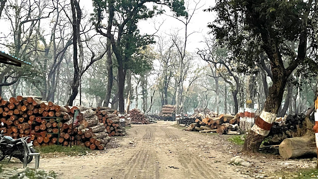 |
The Forest Dept Timber Depot at Khatima (adjacent to Hotel Perchwood)
|
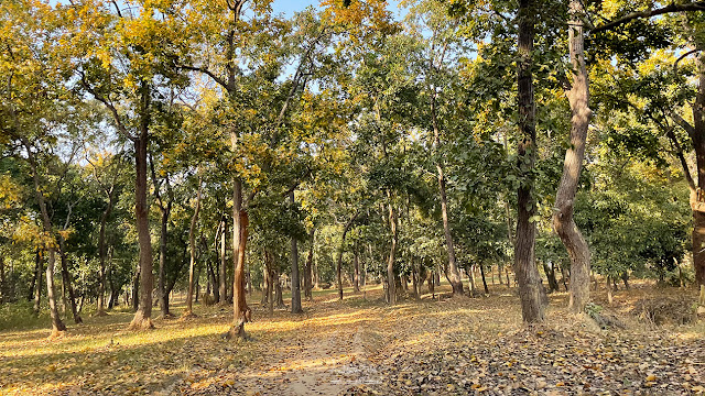 |
The patch of Sal Forest bordering Hotel Perchwood, Khatima
|
Khatima was the last stop on our Terai circuit that commenced from Valmiki
Nagar, a drive covering a little over 800 Km. It is truly fascinating to realise the role of the Himalayas and the numerous rivers that apart from the much needed water supply deposit sand and silt .. the alluvium - that sustains and regenerates the floodplains with fresh growth. A region so critical for sustenance.
The following day (27th Feb) we drove over to
Incredible Birding Camp, Sattal, perched at 1370 metres in the Kumaon foothills
of the Himalayas, in pursuit of the winged wonders of Uttarakhand.
Thanks to Arunava Dutta, for sharing quite a few images that he captured.


Comments
Hope you get to see the elusive wolves at PP!
Raghu